It is significant to understand such a sensitive issue rationally and objectively, rather than solely from an emotional and nationalist perspective. After the Sugauli Treaty, Nepal’s journey has been a roller coaster, with vulnerable domestic politics marked by clashes among the Palace, nobility, political parties, and a trust deficit with our two big neighbors. Our institutions have been weak and unable to translate the aspirations of the people into expected outcomes, as well as limited in handling diplomacy effectively. Through these 12 points, let us examine where we lost our grip and what lessons we should learn from these mistakes.
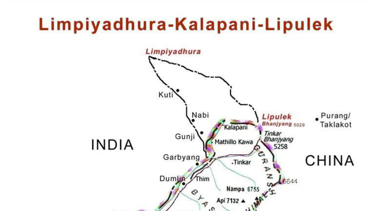
- The long-standing conflict between India and Nepal over Lipulekh, Kalapani, and Limpiyadhura dates back to the Sugauli Treaty of 1816. In Article 5 of the Sugauli Treaty, it states that the King of Nepal renounces all claims to the countries lying to the west of the River Kali. According to this clause, Nepal owns all lands east of the Kali River. However, the treaty did not specify the source of the Kali River or ownership of the river itself. This ambiguity became the root of the conflict.
- In 1996, Nepal and India signed the Treaty of Mahakali. One of its key points was that it recognized the Mahakali River as a boundary river on major stretches between the two countries. While this treaty established that the Mahakali (Kali) River forms the boundary between Nepal and India, it too failed to define the river’s source. Hence, identifying the agreed-upon origin of the Kali River has remained a point of contention since the Sugauli Treaty.
- An administrative and political twist emerged in 1817, when the British Government of India (Governor General’s Secretariat) wrote to George William Traill, the first Commissioner of Kumaon, in response to his communication about disputes in the Byans Pargana (the area that includes Kalapani, Nabi, Kuti, Gunji, etc.). The letter stated: “On examination of the maps transmitted by you and of the facts and circumstances detailed by yourself and Lieutenant Webb, it has left no doubt in the mind of the Governor General that the stream denominated Kala Panee is that which is to be considered as the principal branch of the Kali and as such it is to be held the boundary between the possessions of the two states. As a question of equity and just construction of the Treaty, therefore, our retention of those villages cannot be objected to.” Administratively, the British thus recognized the Kalapani stream not Limpiyadhura as the source of Kali River as early as 1817. Based on this reasoning, the British decided to retain the Byans villages west of Kalapani (such as Gunji, Nabi, and Kuti) within Kumaon (British India), instead of returning them to Nepal. India often cites this letter as proof that the British, just a year after the Sugauli Treaty, officially treated Kalapani as the source of the Kali and used it as the boundary. Countering this, Nepal, argues that, early maps generated by British India (1816–1856) consistently show Limpiyadhura as the source of Kali River. Underlining this, 1817 letter can be seen as merely an administrative convenience, not a faithful interpretation of the treaty.
- The below mentions are the series of maps published by the British India:
| Time Period |
Map / Cartographer |
Kali Source Shown at |
| 1816 | Aaron Arrowsmith – Improved Map of India (2 Jan 1816) | Limpiyadhura |
| 1819 | W. J. Webb – Sketch of Kumaon (1819) | Limpiyadhura |
| 1827 | James Horsburgh (Hydrographer, EIC) – 1 Feb 1827 | Limpiyadhura |
| 1835 | Baldwin & Cradock – Index Map-XII of India (1835) | Limpiyadhura |
| 1837 | J. B. Tassin – Anglo-Asian Map (1837) | Limpiyadhura |
| 1846 | Atlas of India (Society for the Diffusion of Useful Knowledge) | Limpiyadhura |
| 1851 | Himalayan Mountain Reserve Map (1851) | Shows two rivers: one labeled Kali from Limpiyadhura, and another Sharada from Lipulekh |
| 1856 | Surveyor General’s Office (Survey of India) | Limpiyadhura |
| 1857/1859 | Survey of India regional maps (~1857/1859) | Limpiyadhura |
| 1879 | Surveyor General of India (District Almora) |
Source shifted: traditional Kali from Limpiyadhura renamed “Kuti Yangti,” while Lipu Khola (from Lipulekh) labeled as Kali, redefining the boundary |
- Had Nepal protested this 1817 letter, a stronger claim might have been established. However, Nepal had just suffered a heavy defeat in the Anglo-Nepal War (1814–1816), and Prime Minister Bhimsen Thapa, weakened by the territorial losses, was in no position to challenge the Governor General’s decision.
- Nepal also remained silent during the 1954 India-China trade route agreement, which explicitly included Lipulekh. The agreement stated: “Article IV: Traders and pilgrims of both countries may travel by the following passes and routes: (1) Shipki La, (2) Mana Pass, (3) Niti Pass, (4) Kungri Bingri Pass, (5) Darma Pass, and (6) Lipu Lekh Pass.” Once again, there is no record of Nepal objecting at that time.
- Limpiyadhura was located well behind Nepal’s boundary demarcation with China, which began from Tinkar Pass (Pillar No. 1). This was finalized in 1961 during the Nepal–China boundary agreement. Tinkar Pass was marked as the de facto tri-junction, which today serves as strong evidence against Nepal’s current claim over Lipulekh. However, with Nepal’s newly released map incorporating Limpiyadhura, the tri-junction at Tinkar becomes invalid. Establishing a new tri-junction requires the agreement of all three countries—Nepal, India, and China—making the issue even more complicated.
- Then Prime Minister Girija Prasad Koirala raised Kalapani issue with Indian counterparts(said by former Ambassador Bhek Bahadur Thapa) in 1990/91. However, there is a document available online (verification needed) showing that B.B. Karkey, Deputy Director General of the Survey Department of Nepal, in July 1998 signed a paper along with Brigadier M.M.S. Bhanveer, Director of the Northern Circle, Survey of India. This document appears to be from a Joint Working Group meeting between Nepal and India. The document records the Indian side’s statement during the meeting: “The available evidence of tradition, customs, and administrative jurisdiction clearly confirmed that the area in question had been under the jurisdiction of the then Kumaon Province and now Pithoragh District of India since the Treaty of Segowlee. This fact is borne out by revenue records dating back to the 1820s, census and electoral data, and other evidence. A police post has been in existence at Kalapani since 1955.” In addition, the paper states: “Differences over interpretation of the boundary in the area in fact arose shortly after the ratification of the Treaty of Segowlee in March 1816. The disagreements over the ownership of four villages were resolved by the Governor General’s ruling in 1817, which also established that the Kalapani fountain was the source of the River Kali.” In 1998, at the administrative level, Nepal agreed on the source of the River Kali, but later the Nepali side refused to uphold that claim.
- In 2020, the Constitution was amended to add Limpiyadhura, Lipulekh, and Kalapani on the updated map of Nepal. However, Nepal faces serious constraints in pursuing this claim. Given its relative power disadvantage and the non-aggression treaty with India, military options are non-existent. Dialogue is the only path forward, but there is no guarantee Nepal will regain the 100% claimed territory. Even if a compromise deal is reached, Nepal could be forced to cede a small portion—such as one square kilometer—yet this is constitutionally impossible, since Nepal’s Constitution permits territorial expansion but prohibits reduction. Furthermore, before agreeing to negotiations, India might insist that Nepal change its official map, which would pose another political obstacle.
- Being a member of the UN, Nepal is automatically a member of the International Court of Justice (ICJ), as is India. However, India has already stated that it will not take border disputes to the ICJ, preferring instead to settle them bilaterally. Nepal, on the other hand, has not accepted the compulsory jurisdiction of the ICJ under Article 36(2) of the ICJ Statute. This leaves no room for internationalizing the issue.
Conclusion:
Ultimately, Nepal’s argument is on geography and treaty based, which is stronger in legal terms, because the Sugauli Treaty explicitly mentions the Kali River as the boundary river, and early British India maps support Limpiyadhura as its source. India’s argument is on administration and effectiveness, which is stronger in practical terms, because it has exercised long-term control since 1817 and has administrative and legal documents to support its position.
India became a part of the British colony. The British colony always maintained strong institutional records for future reference to avoid any conflict. The Nepali side lacks such documentation and institutional memory, which continues to this day. The lesson for us from this incident is to learn from past mistakes and start building institutional memory and proper archives.